


Australia's big challenges - the role of geoscience

8 July 2014
Dr Chris Pigram
This Insights article is an overview of the keynote presentation by Geoscience Australia's Chief Executive Officer Dr Pigram at the 2014 Australian Earth Sciences Convention.
Australia is a very large but sparsely populated continent which has always been shaped by its geology and geography. To help the nation respond to current and future challenges, Geoscience Australia is focussing on six key challenges as drivers for its work. This presentation uses case studies to illustrate how Geoscience Australia is helping to address these six challenges.
Building Australia's Resource Wealth
Australia has a strong reputation for world class mineral deposits; however the number of discoveries of large ore deposits has decreased in the last ten years. This has led to a common perception of Australia as 'mature' in relation to mineral exploration and discovery.
This perception is influenced by the fact that much of Australia's prospective rocks are covered by younger sediments. Figure 1 shows that major known mineral deposits are mostly located within areas of rock outcrop or shallow cover. However, many world class mineral provinces extend for considerable distances beneath the cover of transported sediments. These areas of basement geology concealed by shallow cover represent major new exploration opportunities.
Geoscience Australia's work to support mineral exploration is focussed on developing new techniques and approaches to see through this cover material to assess mineral prospectivity. This work is shaped by the Australian Academy of Science's UNCOVER Initiative, which is seeking to achieve a step change in knowledge and methodologies in Earth sciences in relation to mineral exploration under transported sediments.
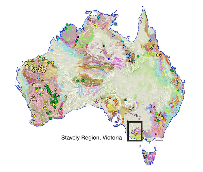
Figure 1: Geoscience Australia is currently working in
collaboration with the Geological Survey of
Victoria and the Deep Exploration Technologies
CRC (DETCRC) on a stratigraphic drilling
project in the Stavely region of western
Victoria as part of the UNCOVER initiative.
In this context, Geoscience Australia is currently working in collaboration with the Geological Survey of Victoria and the Deep Exploration Technologies Cooperative Research Centre (DETCRC) on a stratigraphic drilling project in the Stavely region of western Victoria. The project aims to increase the investment attractiveness of this under-explored region by reducing exploration risk through an improved understanding of the subsurface geology.
In regards to Australia's conventional and unconventional oil and gas resources, Geoscience Australia has a three-pronged strategy designed to reveal the hydrocarbon potential of our nation. This work involves basin analysis of offshore basins, regional studies and targeted petroleum systems studies for onshore basins. As part of this work, Geoscience Australia is working towards a synthesis and analysis of all available geoscientific data and information relevant to petroleum prospectivity for each of Australia's frontier basins.
Geoscience Australia hopes to repeat the recent success it had in supporting the boost in petroleum exploration efforts in the Bight Basin. A phase of unsuccessful exploration in this basin in the early 2000s resulted in many companies considering the basin too risky for further exploration. However, Geoscience Australia continued to see potential in the basin. A marine survey conducted during 2007 by Geoscience Australia used targeted dredging, directed by seismic analysis and geological models to predict where possible source rocks could outcrop on the seafloor.
The survey successfully recovered samples of oil prone source rocks. This discovery was followed by petroleum systems modelling, which confirmed the right conditions to develop a petroleum system. These efforts, which cost a total of $6.6 million, have has resulted in many companies now exploring in the Bight Basin, with committed exploration programs now in excess of one billion dollars and nine wells scheduled to be drilled.
Securing Australia's Water Resources
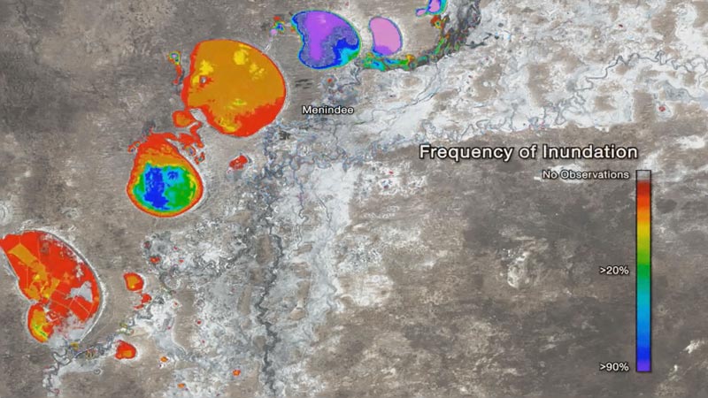
A Landsat dataset showing movement of
surface water in this area over a 7 year period
from 2003-10 in the Menindee Lakes of
the Broken Hill region.
Another part of Geoscience Australia's remit is to develop new and innovative geoscience to optimise and sustain the use of Australia's groundwater resources. Recent work undertaken by Geoscience Australia as part of the Broken Hill Managed Aquifer Recharge Project aimed to identify and assess current groundwater resources and managed aquifer recharge options for the Broken Hill region.
This region was historically data poor. Collection of new data, including airborne electromagnetics (AEM), a light detection and ranging (LIDAR) digital elevation model, and borehole data has enabled an increased understanding of the hydrogeology, variations in groundwater salinity and the significance of neotectonic faulting on the geology and its potential impact on groundwater resources. The AEM data in particular revealed fault off-sets which provide interconnectivity between aquifers, with major implications for aquifer recharge during flooding and for the integrated management of water in the aquifers.
Providing Fundamental Geographic Information
Geoscience Australia's operational geospatial capability supports understanding positional needs of Australia; including monitoring real-time changes in the structure of the continent via geodesy, Global Navigation Satellite System (GNSS) and seismic networks. This work is integral to facilitating better access to accurate positioning.
Australia has a geographic advantage as a GNSS hotspot, as one of only a few countries able to see all the new and emerging navigation satellite systems. With the next generation of GNSS, augmented by well-designed ground infrastructure, 2cm accurate positioning anywhere in Australia using small devices is likely to be achieved by 2020. This work is vital to applications such as GPS navigation, industrial automation, precision farming, land subsidence and weather forecasting; and in the near future will underpin technologies such as autonomous cars.
Maintaining Australia's Geoscience Knowledge and Capability
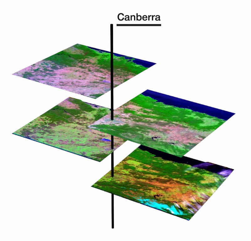
An example of the output from the Geoscience
Australia Data Cube showing Landsat
satellite images of Canberra from different
satellite paths which need to be rectified
or re-located.
Recent advances in high performance computing are allowing us to move towards a more holistic Earth System view. These advances are particularly relevant to the management, distribution and interpretation of enormous and ever growing datasets acquired by Earth observation satellites. An excellent example of this work is the Australian Geoscience Data Cube project which is enabling better access the entire national archive of Landsat satellite imagery held by Geoscience Australia. This massive archive is now stored in the supercomputer of the National Computational Infrastructure facility at the Australian National University, providing a processing platform that allows systematic analysis of every observation made by the Landsat satellites over the last 25 years.
Potential applications of the Australian Geoscience Data Cube include rapid analysis of change through time in the Australian landscape; providing a mechanism to establish robust environmental baselines, and to monitor changes in the landscape over time, including the presence or absence of water, land use variations, and vegetation recovery from major events such as floods and fires.
Managing Australia's marine jurisdiction
Managing Australia's marine jurisdiction is a large challenge, since it is a vast and data-poor area, representing four per cent of the global oceans and 1.8 times the size of the Australian land mass. Geoscience Australia's role is to provide geoscience baseline data to underpin the management of this vast jurisdiction. The geoscience baseline information has the potential to provide an underpinning fundamental dataset with which to establish an environmental baseline for the nation's marine estate.
A new national mapping program of this vast area is critical to its sustainable management. New bathymetric surveys are needed, to not only replace existing coarse regional bathymetric datasets with much higher resolution data, but also to collect new types of data, such as backscatter which can be used to identify the nature of seafloor. Geoscience Australia's capability to process and interpret bathymetric data and integrate that with other geoscience information can be applied in support of appropriate planning responses to resource and environmental issues, including resource and fisheries development and the protection of marine biodiversity.
Ensuring Australia's community safety
Geoscience Australia also works to support Australia's capability to manage the impact of natural hazards, with the overall aim of ensuring Australia's community safety. This work provides geoscience understanding to assist the mitigation of, and response to, natural hazards including earthquakes, bushfires, floods, severe winds, and even volcanic eruptions.
Geoscience Australia continues to update its earthquake hazard modelling, to support development of better building codes and enhanced emergency management. Further to this Geoscience Australia is also working with a range of partners across the Australian Government to share our natural hazard modelling capabilities within the Asia-Pacific region, including countries such as Indonesia, Papua New Guinea and the Philippines.
Conclusion
The Earth sciences play a critical role in helping Australia to respond to major economic, social and environmental challenges now and into the future. In this context, it is vital for geoscientists to recognise the need to deliver high-quality datasets and value-added products, and to provide impartial evidence-based science and advice. We also must show leadership in developing innovative methods to use and re-use data and technologies to help meet new challenges.