


Celebrating 70 years of trusted geological advice
18 March 2016
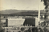
Historical photo of the Bureau of Mineral
Resources building opened in 1965 located
in Anzac Parade East in Canberra
Geoscience Australia is celebrating 70 years as the nation's trusted geological advisor, marking the decision to establish the Bureau of Mineral Resources, Geology and Geophysics (BMR) on 20 March 1946.
Driven by efforts to reinvigorate the mining industry during post-war reconstruction, a Sub-Committee of Prime Minister Chifley's Cabinet approved a recommendation to set up a Commonwealth geological survey comparable to those of the United States and Canada.
The BMR's main objective was the systematic geological and geophysical mapping of the continent to determine the extent and distribution of the nation's mineral and energy wealth. Over three decades, it conducted first-pass mapping of all offshore areas of the Australian continental margin, and collaborated with state and Northern Territory geological surveys to complete mapping of onshore areas. The benefits were clearly demonstrated by the expansion of the mining and petroleum industries across this period, particularly the mining boom of the 1960s.
The success of the BMR has been largely credited to the visionary leadership of founding Director Sir Harold Raggatt, supported by Chief Geologist N. H. 'Doc' Fisher and Chief Geophysicist Jack Rayner. Their enthusiasm reflected the extraordinary confidence that many Australians had in the nation's future following World War II.
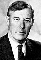
Founding Director
Sir Harold Raggatt.
Credit: Australian Academy of Science
The organisation's name changed to Australian Geological Survey Organisation (AGSO) in 1992, before merging with the Australian Surveying and Land Information Group (AUSLIG) in 2001 to become Geoscience Australia.
Geoscience Australia now applies its capabilities to a wide range of opportunities and challenges facing our nation. This includes maximising value from our abundant mineral and energy resources; providing the fundamental geographic information to develop the nation; sustainably managing our vast marine environment, securing water on our dry continent; and protecting communities from natural disasters.
This takes the organisation well beyond the original focus on resource mapping and development. Geoscience Australia's work now extends across the Australian continent into our vast marine jurisdiction and Antarctic territories; as well as realising the benefits of advances in satellite technology to enable safer navigation and observations from space.
Further information:
- Geoscience Australia's Value to the Nation publication