


Secrets of Darwin Harbour - from sand waves to shipwrecks
1 December 2015
Darwin is world renowned for its rich and diverse landscapes, but as a scientific exploration party has just discovered, there is an equally diverse and until now undiscovered region of Darwin under the sea. A marine survey tasked to map the seabed of Darwin Harbour in high resolution and collect geochemical and physical samples has found relicts of Australia's ancient geography in the form of sub-marine sand dunes, ripples and sand waves.
These features tell a story from the last ice age some 20 000 years ago when global sea levels were much lower and Darwin Harbour did not exist as we know it today. During this time a land-bridge existed between northern Australia and New Guinea, and Darwin was potentially only a river valley until an estuary developed when rising seas drowned the area around 7000-8000 years ago.
"This crucial research significantly enhances our efforts for better estuary and coastal management of this area, while creating the best mapped tropical macro-tidal system in the world. It's also an exciting test case for scientists who hope to better understand complex environmental systems like Darwin Harbour", said Neil Smit, a scientist in the Northern Territory Government.
Geoscience Australia was asked to partner the Northern Territory Government in this research bringing over 50 years' experience in sea floor mapping which has underpinned exponential growth in building Australia's understanding of the marine environment. They will continue to collaborate on this research for the duration of the four-year program.
The survey has also provided a new generation of accurate and detailed imagery of historic shipwrecks in Darwin Harbour. These include the USAT Meigs (sunk during the bombing of Darwin in 1942) and the Booya (pictured) which sank during Cyclone Tracy in 1974.
"These images are a great contribution to our continuous efforts to better understand our marine archaeology, and to manage these historic shipwrecks in Darwin Harbour", said David Steinberg a Senior Heritage Officer of the Northern Territory Government.
Armed with an increased understanding of the marine environment, the Northern Territory Government will be able to make the most informed decisions in terms of the ongoing management and development of the Harbour.The survey was undertaken by the Northern Territory Government in conjunction with Geoscience Australia and the Australian Institute of Marine Science, and is supported by funding from Ichthys LNG Project.
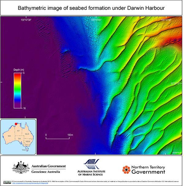
Coloured bathymetric image of underwater ripple formations and sand waves on the Darwin Harbour sea floor
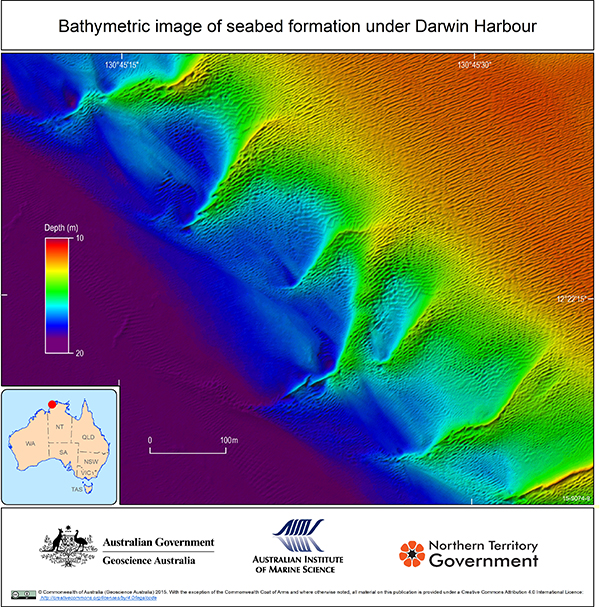
Coloured bathymetric image of underwater sand waves on the Darwin Harbour sea floor
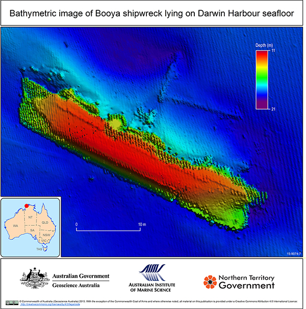
Coloured bathymetric image of a ship lying on its side on the Darwin Harbour sea floor
Watch the video of the surveys completed in Darwin Harbour during 2011 and 2013.