


The LINK to spatially located data is here
5 April 2017
The launch of ANZLIC's new Location INformation Knowledge (LINK) Platform delivers an exciting new era of open access to essential spatial datasets across all levels of Australian government.
Developed by Geoscience Australia in collaboration with ANZLIC - The Spatial Information Council and the Department of Prime Minister and Cabinet, together with the states and territories, LINK represents a major achievement in delivering open public data via cloud services.
It takes the conceptual Foundation Spatial Data Framework (FSDF), first published in 2012, and delivers a comprehensive online knowledge base. This is a significant collaborative effort across all levels of government, and is another step towards developing a truly national approach for spatial data information.
The addition of contextual information is a world first directory of Australia's first enabling government and industry users, such as town planners and engineers, to easily identify key government spatial datasets across the 10 FSDF data themes. The LINK facilitates access to essential information about where and how to access hundreds of jurisdictional datasets that contribute to the national spatial data holdings, and the relationships and dependencies between these datasets.
The extensive range of FSDF datasets now available via LINK help define locations and spatial extent of a range of data in themes from administrative boundaries, place names, land and property information, geocoded addresses through to accessing satellite imagery and land use information. This supports a range of applications including, but not limited to, agriculture, utilities, transport and emergency services.
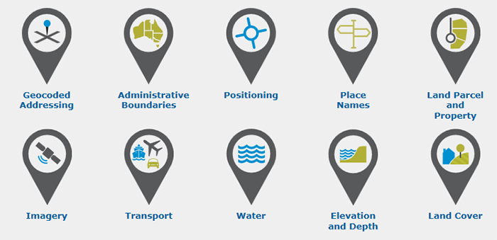
The key themes of the Foundation Spatial Data Framework (FSDF)
A single source for Australian spatial data
Chief of Geoscience Australia's Environmental Geoscience Division Dr Stuart Minchin explained that providing the FSDF datasets via one portal now ensures we can have a nationwide seamless exchange of spatial data.
"This makes these fundamental datasets far more discoverable and accessible, and contributes to the government's broader vision of enabling the use of high value spatial data to assist in effective environmental, social and economic policy development," Dr Minchin said.
"Users are able to discover trusted location information, learn more about governance and provenance of the data, and access a wide variety of location information data supplied by the Australian, state and territory governments," he added.
The LINK provides detailed supply chain information for the datasets and related intelligence data. This includes open access to information on which agency supplies the data, how the data is managed, where the products go and which agency is responsible for components within the supply chain. LINK will be automatically updated by harvesting the metadata from the datasets when they are updated by the source agency.

The Location INformation Knowledge (LINK) Platform provides a single portal for Australia's spatial datasets.
The launch of LINK coincided with the Digital Earth & Locate 17 conference, providing an opportunity for government, industry and start-ups to discuss and collaborate on new ideas and technologies for smart cities that can be exported around the globe. The theme 'Smart Cities' is already an emerging priority in many parts of the world, with countless opportunities for knowledge-based enterprises, including the spatial sector.
Further information:
- Ministerial Media Release: Government location data now available at LINK
- Location INformation Knowledge Platform (LINK)
- Foundation Spatial Data Framework
- National Positioning Infrastructure Capability
Home page web banner image credit: Seb Zurcher