


UNCOVER: unlocking Australia's hidden mineral potential

7 July 2014
Dr Richard Blewett
It is becoming increasingly difficult to discover near-surface mineral resources in Australia. New and innovative products and techniques are being developed as part of the UNCOVER Initiative to help attract mineral exploration investment that has the potential to lead to the discovery of new resources.
Australia's economic prosperity is highly dependent on the continent's remarkable endowment of mineral and energy resources. Maintaining this prosperity requires effective exploration that leads to new discoveries to provide an ongoing 'pipeline' of resource development.
A number of presentations being given by Geoscience Australia geoscientists at this year's Australian Earth Sciences Convention are delivering insights into current work being undertaken to support what is essentially a paradigm shift in mineral exploration.
Unfortunately, the percentage of global expenditure for minerals exploration in Australia has declined over the past decade, particularly for non-ferrous commodities and in frontier or 'greenfields' regions. One factor for the decline in expenditure has been the perception that Australia is 'mature', with limited prospects for big new discoveries. The decline in exploration success is in large part due to the difficulty in exploring what lies beneath vast swathes of highly weathered rock, known as regolith, and sedimentary basins that cover approximately 80 per cent of Australia.
The Searching the deep Earth: a vision for exploration geoscience in Australia strategy, which is now being led and implemented by the Australian Academy of Science as the UNCOVER Initiative, is a call to the exploration geoscience community in industry, government and academia to collaborate on a scale not previously attempted in Australia. This strategy ensures Australia has a magnificent opportunity to lead the world in under cover exploration.
The ultimate goal of the UNCOVER Initiative is to achieve a step change in knowledge and methodologies in Earth sciences which is relevant to mineral exploration beneath the cover. This will be achieved through the four themes of the Initiative:
- Characterising Australia's cover
- Investigating Australia's lithospheric architecture
- Resolving the 4D geodynamic and metallogenic evolution of Australia
- Characterising and detecting distal footprints of mineralization.
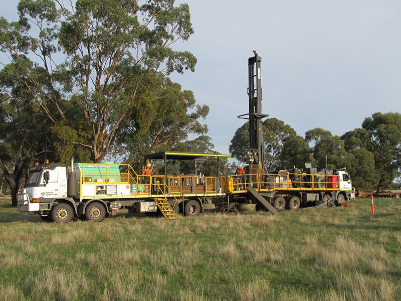
Sonic rig drilling of the Murray Basin cover
rocks that overlie the prospective Stavely
Volcanic Complex.
Geoscience Australia and the Geological Survey of Victoria are collaborating on a stratigraphic drilling project in the Stavely region of western Victoria. The project is aimed at increasing the investment attractiveness of this under-explored region by reducing exploration risk through an improved understanding of the subsurface geology.
A series of stratigraphic boreholes are currently being drilled through cover rocks into the volcanic rock basement to test the underlying geological and mineral systems models. The drilling tests include determining the stratigraphic continuity of the prospective Stavely Volcanic Complex, sampling buried intrusions that are possible hosts to porphyry-epithermal mineralisation and testing key structures in the region. Further knowledge gained will be a better understanding of the depth and nature of cover including the cover sequence stratigraphy and whether any detectable geochemical dispersion occurs between the basement rocks, cover rocks and regolith. The results from these drill holes will add significantly to the pre-competitive knowledge base of this greenfields region.
In the areas of deeper cover, pre-collar holes where drilled using the sonic method, which will be later drilled with diamond tails. The sonic method, when applied to unconsolidated sediments, has the advantage of being quicker than conventional diamond drilling; it is also able to recover almost complete and intact core. The recently drilled 212 m-deep Stavely hole 14, located in the southern part of the Murray Basin near Nhill, has the honour of being the deepest of its kind in the Southern Hemisphere. The resultant core is arguably the best recovered sample of this important basin.
The diamond drilling is utilising the latest technology from the Deep Exploration Technologies Cooperative Research Centre (DET CRC), including the Autosonde¿ borehole geophysical tool and the top-of-hole Lab-At-Rig¿ geochemistry. Results to date are very encouraging with significant alteration systems being identified in a number of holes.
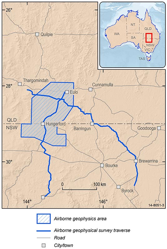
Another focus region for the UNCOVER Initiative is the Thomson Orogen. The Thomson Orogen is a large area that lies to the north and west of the Lachlan Orogen in New South Wales, South Australia, the Northern Territory and Queensland. Much of it is under the cover of younger sedimentary basins, with some up to several kilometres thick, and it is therefore a poorly understood element of Australia's geology.
The southern Thomson Orogen is true 'greenfields' country. Although the mineral potential of the region is largely unknown, the northeastern Thomson Orogen (for example Thalanga, Charters Towers) and the similar-aged Lachlan Orogen to the south are well mineralised (for example Cadia, Northparkes, Lake Cowall Cobar). In order to attract exploration investment into the southern Thomson Orogen, and also to improve the geological understanding of the area, Geoscience Australia, the Geological Survey of Queensland and the Geological Survey of New South Wales have commenced a collaborative project to collect new (and synthesise existing) pre-competitive data.
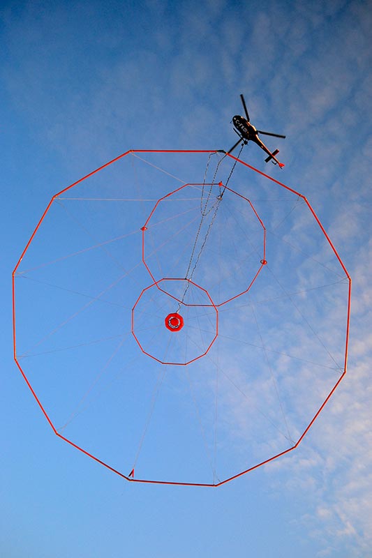
The Geotech VTEM FullWaveForm
airborne electromagnetic acquisition
system used in the Southern Thomson
Orogen airborne electromagnetics survey.
Image credit: Geotech Airborne Limited.
One of the first steps in this collaboration is to acquire airborne and ground geophysical data including airborne electromagnetics (AEM), gravity and magnetotelluric (MT) data. Regional AEM data has now been collected to map cover thickness and assess the geology and prospectivity of the Southern Thomson Orogen across the New South Wales-Queensland border around Hungerford and Eulo. These data will be interpreted using existing borehole stratigraphic data and a new solid geology compilation of the region developed between Geoscience Australia, the Geological Survey of Queensland and the Geological Survey of New South Wales.
Geoscience Australia is a leading promoter of AEM surveying for regional mapping of cover thickness, under-cover basement geology and sedimentary basin architecture. Geoscience Australia flew three regional AEM surveys during the 2006-11 Onshore Energy Security Program (OESP): Paterson (Western Australia, 2007-08); Pine Creek-Kombolgie (Northern Territory, 2009); and Frome (South Australia, 2010) [1]. The surveys were primarily designed to provide reliable, fit-for-purpose pre-competitive AEM data for mapping critical features of uranium mineral systems.
Results from these surveys have now produced a new understanding of the architecture of critical mineral system elements and mineral prospectivity for a wide range of commodities of these regions and includes details on the thickness and character of the regolith, sedimentary basins and buried basement terrains. The data have since been found suitable not just for uranium, but for mapping a range of other mineral systems including gold, silver, copper, lead, zinc and potash, as well as for under-cover geological mapping and groundwater resource estimation.
Airborne electromagnetic data
acquisition in the Southern Thomson
Orogen Project area.
The survey data are now processed using the National Computational Infrastructure (NCI) facility at the Australian National University to produce GIS-ready interpretation products and GOCADTM objects suitable for 3D modelling.
A number of 3D models are being developed to interpret the near-surface under-cover geology of cratons and mobile zones, the unconformity surfaces between these and the overlying sedimentary basins, and the architecture of those basins. These models are constructed primarily from AEM data using stratigraphic borehole control and show how AEM data can be used to map the cross-over area between surface geological mapping, stratigraphic drilling and seismic reflection mapping. These models can be used by minerals explorers to more confidently explore in areas of shallow to moderate sedimentary basin cover by providing more accurate cover thickness and depth to target information. A 3D model of basement-cover relationships and depth of cover will be developed for the southern Thomson Orogen.
The Southern Thomson Orogen AEM Survey dataset is due for release shortly.
Further information:
References
[1] ^ I. C. Roach, S. Jaireth & M. T. Costelloe (2014): Applying regional airborne electromagnetic (AEM) surveying to understand the architecture of sandstone-hosted uranium mineral systems in the Callabonna Sub-basin, Lake Frome region, South Australia, Australian Journal of Earth Sciences: An International Geoscience Journal of the Geological Society of Australia, DOI:10.1080/08120099.2014.908951