Mineral exploration
Last updated:24 July 2023
Geophysical Maps and Images
The methods available for display of processed geophysical data (gravity, airborne electromagnetics, passive seismic, active seismic, magnetotellurics, magnetic, radiometric, elevation and others) include discrete point data, contour maps and grids, line profiles, raster image maps, 3D images, and cross sections.
The line, or stacked profile shows fine detail along the line of acquisition that is not as visible in the display of data by grids and images. Geoscience Australia and State Government Geological agencies produce grids and raster images for display of geophysical data as the utility of Geographical Information Systems (GIS) allows for the simultaneous display of geophysical data with other geospatial datasets.
In order to produce continuous grids and images that allow visualisation of features and trends in the data, the recorded station or flight-line measurements are subject to a standard gridding process. The recorded geophysical data along each flight-line is resampled to equally spaced data points along the flight lines, and interpolated. Similarly, interpolation between flight lines is conducted using equally spaced data samples by making some basic assumptions about how the data trends orthogonal to survey lines. The whole process generates an equally spaced grid. The gridded data sample interval, or cell size, is usually chosen to be one-quarter to one-fifth of the survey line spacing. The appropriate cell size is chosen as a balance between having a grid with too many redundant cells and having large gaps, or excessive interpolation between cells.
Geophysical image maps can be shown as black and white or colour images. Images displayed with a full colour scheme typically use the warmer colours (reds and oranges) to represent areas of higher values, such as magnetic intensity, conductivity or density, and the cooler colours (greens and blues) to represent areas of lesser values. Sun illumination can also be applied to emphasise geological trends in different directions.
Images can be enhanced also by the application of various filtering and transformation processes to produce images with enhanced information content. For example, magnetic data can be subject to a process called ‘Reduction to the Pole’ (RTP) in which the recorded data are converted to what they would have looked like if the magnetic field had been vertical rather than as recorded in the Earth’s inclined magnetic field. Articles which describe the vast array of additional enhancements for geophysical data are available through Geoscience Australia’s Data and Publications catalogue .
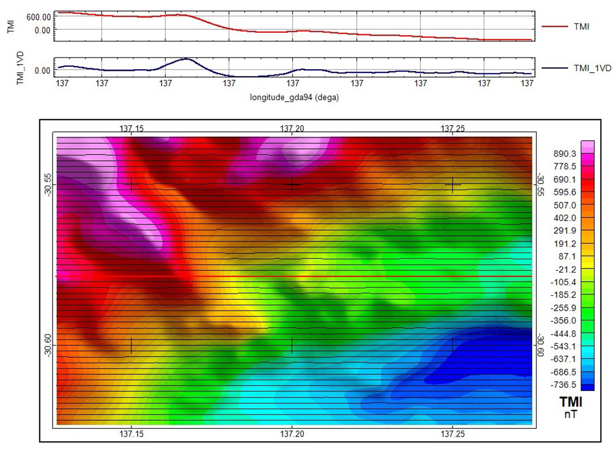
Magnetic profile data with corresponding raster image.
Mineral Exploration Legislation, Reporting Guidelines and Exploration
Mineral Exploration legislation and regulation in Australia is undertaken by the Australian State and Territory governments.
Mineral Deposits Mineral Systems and Mineralising Events
The Australian continent hosts many mineral commodities in a range of mineral deposit types distributed in all states and the Northern Territory. The distribution of Australia's mineral deposits is shown on the Australian Mines and Mineral Deposits. Maps and resource data of Australian mineral deposits and mineral occurrences are available through the Australian Mines Atlas, an on-line information and mapping system.
Mineral deposits are naturally occurring accumulations or concentrations of metals or minerals of sufficient size and concentration that might, under favourable circumstances, have economic value. Economic concentrations of metals or other mineral commodities are known as ore. Mineral resources are naturally occurring concentrations of minerals that are potentially economic to extract. These are classified according to the degree of geological assurance and economic feasibility based on the McKelvey resource classification system and compiled in the national resource inventory described in Australia's Identified Mineral Resources.
The distribution of mineral deposits is determined by the geological processes that formed them. Mineral deposits are therefore commonly clustered in geological provinces (mineral provinces or mineral districts) with some provinces being strongly endowed in particular mineral commodities (Jaireth and Huston, 2010). An example is the Hamersley Basin in the Pilbara which hosts most of Australia's known iron ore deposits and resources. Maps showing the distribution of Australia's major deposits and endowment by region for the major commodities (coal, copper, gold, iron ore, minerals sands, nickel, phosphate rock, lead and zinc) are available at Minerals maps.
The distribution of mineral deposits is also determined by the timing of ore forming processes. Ore deposits have formed at various periods over geological time from at least 3500 million years ago to the present day where mineral deposits are forming as part of natural earth processes both on land and on the sea-floor. Deposits have commonly formed through a combination of geological factors closely related in time. Advances in the dating of geological processes have shown that many ore deposits formed over a relatively short time period associated with particular geological processes. These mineralising events punctuate geological time, many have been repeated throughout the geological record, and most can be related to tectonic events.
Mineral deposits have historically been classified according to a number of geological parameters including their geological setting, host rocks, or conceptual models of formation. The most widely adopted, especially for resource assessments, is the mineral deposit models classification of Cox and Singer (1992) published by the USGS, which includes grade and tonnage models. A modified version of these mineral deposit models for Australia's major mineral deposit types is available on the Australian Mines Atlas. Australia's mineral deposits are described in the AUSIMM monographs on the Geology and Mineral Deposits of Australia and Papua New Guinea. Solomon and Groves (1994, updated 2000) provide a comprehensive synthesis of the geology and origin of Australia's mineral deposits. A summary of the exploration models for major Australia mineral deposit types is published in the AGSO Journal of Geology and Geophysics, vol.17 no. 4.
The mineral systems approach to mineral deposit genesis, originally proposed by Wyborn et al (1994), attempts to provide a framework that considers all the geological processes that control the formation and preservation of mineral deposits. An overview of the major mineral systems of Australia is given by Jaques et al. (2002). The mineral systems approach was extended through the work of the Predictive Mineral Discovery Cooperative Research Centre to include five major questions that provide key information on the geodynamic and geological settings and other parameters associated with the genesis of the deposit. The mineral systems concept has been further extended by Fraser et al. (2007) and places the deposit models and types in a systems framework that includes geodynamic environment, tectonic setting, and fluid/magma involved in mineralisation. Geoscience Australia's Mineral Systems Section uses this approach to increase the understanding of Australia's mineral prospectivity, particularly for economically and strategically important minerals.
Table 1: Geodynamic and tectonic classification of mineral systems
| Geodynamic environment | Tectonic setting | Mineral system group | Deposit type | Metal association | Fluids and magma |
|---|---|---|---|---|---|
| Convergent-extensional | Continental backarc | Basin-related fluid flow, with active magmatism | Carlin-type | Au-Ag-As-Sb-Hg | Meteroric magmatic-hydrothermal |
| BHT/Sullivan-type Zn-Pb-Ag | Zn-Pb-Ag-Cu-Au | Basinal brines | |||
| Kuroko-type VAMS | Zn-Cu-Pb-Ag-Au | Evolved seawater; magmatic-hydrothermal | |||
| Algoma-type BIF | Fe | Evolved seawater | |||
| Magmatic-related hydro thermal | Intrusion-related Au | Au-Ag-Sb-Cu-Pb-Zn-Sn-W-Mo-Bi-Te | Magmatic-hydrothermal; metamorphic | ||
| Olympic Dam-type IOCG | Fe-Cu-Au-Ag-U-REE-Co-Mo-P-Nb | Magmatic-hydrothermal, meteoric | |||
| Cloncurry-type IOCG | Fe-Cu-Au-Ag-As-Co-Mo-P | Magmatic-hydrothermal, metamorphic | |||
| Convergent-extensional | Island backarc | Basin-related fluid flow, with active magmatism | Kuroko-type VAMS | Zn-Cu-Pb-Ag-Au | Evolved seawater; magmatic-hyrdrothermal |
| Cyprus style VAMS | Cu-Zn-Co-Ag-Au | Evolved seawater; magmatic-hyrdrothermal | |||
| Algoma-type BIF | Fe | Evolved seawater | |||
| Ortho-magmatic | Podiform chromite | Cr | Tholeiitic ultramafic magmas | ||
| Convergent-contractional | Continental arc | Magmatic-related hydro-thermal | Porphyry | Cu-Au-Ag-Mo | Magmatic-hydrothermal |
| Epithermal (adularia-sericite) | Au-Ag | Meteoric; magmatic-hydrothermal | |||
| Epithermal (advanced argillic) | Au-Cu-Ag | Magmatic-hydrothermal | |||
| Skarn | Fe-Cu-Zn-Pb-Sn-W-Mo | Magmatic-hydrothermal | |||
| Candelaria style IOCG | Fe-Cu-Au-Ag-U-As-Co-Mo-P-Nb-Ni-REE | Magmatic-hydrothermal | |||
| Ortho-magmatic | Intrusion-hosted Ni-Cu-PGE | Ni-Cu-Pt-Pd-Au-Co | Tholeiitic mafic magmas | ||
| Strata-bound Cr-PGE | Cr-Pt-Pd | Tholeiitic mafic-ultramafic magmas | |||
| Merensky Reef-type Ni-PGE | Ni-Pt-Pd | Tholeiitic mafic-ultramafic magmas | |||
| Podiform chromite | Cr | Tholeiitic ultramafic magmas | |||
| Convergent-contractional | Island arc | Magmatic-related hydro-thermal | Porphyry | Cu-Au-Ag-Mo | Magmatic-hydrothermal |
| Epithermal (adularia-sericite) | Au-Ag | Meteoric; magmatic-hydrothermal | |||
| Epithermal (advanced argillic) | Au-Cu-Ag | Magmatic hydrothermal | |||
| Skarn | Fe-Cu-Zn-Pb-Sn-W-Mo | Magmatic hydrothermal | |||
| Forearc accretionary wedge | Not known | ||||
| Forearc basin | Magmatic-related hydro-thermal | Intrusion-related Au | Au-Ag-Sb-Cu-Pb-Zn-Sn-W-Mo-Bi-Te | Magmatic-hydrothermal; metamorphic | |
| Weathering and regolith, physical concentration, reduced atmosphere | Palaeo-placer Au-U | Au-U-Pt-Pd | Meteroric | ||
| Pro-foreland | Not known | ||||
| Retro-foreland | Basin-related fluid flow, without active magmatism | MVT style Pb-Ag-Zn | Zn-Pb-Ag | Basinal brines | |
| Collisional | Deformation and metamorphism | Lode Au | Au-Ag-As-Sb-Te-W-Bi | Metamorphic; magmatic-hydrothermal | |
| Mt Isa type Cu | Cu | Metamorphic | |||
| Cobar style Pb-Zn-Cu-Au | Pb-Zn-Ag-Cu-Au | Metamorphic | |||
| Tennant Creek-type IOCG | Cu-Au-Bi-Se-Pb-Zn-U | Magmatic-hydrothermal, basinal brines and metamorphic | |||
| Divergent | Mid-oceanic ridge | Basin-related fluid flow, with active magmatism | Cyprus style VAMS | Cu-Zn-Co-Ag-Au | Evolved seawater; magmatic-hydrothermal |
| Ortho-magmatic | Ophiolite hosted Cr, Ni | Cr-Ni | Mafic magmas | ||
| Continental rift | Basin-related fluid flow, with active magmatism | BHT/Sullivan-type | Zn-Pb-Ag-Cu-Au | Basinal brines | |
| Ortho-magmatic | Carbonatite-hosted REE | REE-P-F-Mo-Cu-Pb-Zn | Alkaline carbonatitic magmas | ||
| Diamonds | Dia-mond | Alkaline ultramafic magmas | |||
| REE and P-rich nepheline syenite | REE-P-F | Alkaline felsic magmas | |||
| Anorthosite-hosted Fe-Ti-V | Fe-Ti-V | Tholeiitic mafic magmas | |||
| Intrusion-hosted Ni-Cu-PGE | Ni-Cu-Pt-Pd-Au-Co | Tholeiitic mafic magmas | |||
| Komatiitic-hosted nickel sulphide | Ni-Cu-Pt-Pd-Au | Komatiitic mafic magmas | |||
| Rifted arc | Basin-related fluid flow, with active magmatism | Kuroko-type VAMS | Zn-Cu-Pb-Ag-Au | Evolved seawater; magmatic-hydrothermal | |
| Algoma-type BIF | Fe | Evolved seawater | |||
| Magmatic-related hydro-thermal | Epithermal (adularia-sericite) | Au-Ag | Meteoric; magmatic-hydrothermal | ||
| Hotspot | Oceanic | Basin-related fluid flow, with active magmatism | Cyprus style VAMS | Cu-Zn-Co-Ag-Au | Evolved seawater; magmatic-hydrothermal |
| Continental | Ortho-magmatic | Flood-basalt associated Ni-Cu-PGE | Ni-Cu-Pt-Pd-Au-Co | Mafic magmas | |
| Intraplate | Ocean basin | Sedimentary | Mn-Ni-Co-nodules | Mn-Ni-Co | Oxidized seawater |
| Passive margin | Sedimentary | Hammersley-type BIF | Fe | Reduced seawater | |
| Sedimentary manganese | Mn-Ni-Co | Reduced seawater | |||
| Sedimentary sulphate | SO4-Ca-Ba | Oxidized seawater | |||
| Sedimentary phosphate | P | Oxidized seawater | |||
| Basin-related fluid flow, without active magmatism | Mt Isa-type Zn-Pb-Ag | Zn-Pb-Ag | Basinal brines | ||
| Distal contraction | Basin-related fluid flow, without active magmatism | MVT style Pb-Ag-Zn | Zn-Pb-Ag | Basinal brines | |
| Irish-style Pb-Zn | Zn-Pb-Ag | Basinal brines | |||
| Sediment-hosted Cu-Co | Cu-Co-Ag | Basinal brines | |||
| Unconformity U | U-P-REE-Cu-Au | Basinal brines | |||
| Kipushi type Cu-Zn-Pb | Cu-Zn-Pb | ? | |||
| Laisval-type Pb | Pb | Basinal brines | |||
| Inactive continental | Basin-related fluid flow, without active magmatism | Rollfront-palaeo- channel U | U-P-REE | Basinal brines | |
| Weathering and regolith, chemical concentration | Lateritic Ni | Ni-Au | Meteoric | ||
| Lateritic bauxite | Al | Meteoric | |||
| Calcrete Au-U | Au, U | Meteoric | |||
| Supergene enrichment | Au-Cu-Pb-Zn | Meteoric | |||
| Placer Ti-Zr-Th-Hf | Ti-Zr-Th-Hf | Meteoric | |||
| Placer Au | Au | Meteoric | |||
| Placer Sn-Ta | Sn-Ta | Meteoric | |||
| Weathering and regolith, physical concentration | Placer Ti-Zr-Th-Hf | Ti-Zr-Th-Hf | Meteoric | ||
| Placer Au | Au | Meteoric | |||
| Placer Sn-Ta | Sn-Ta | Meteoric | |||
| Variable | Orthomagmatic | Pegmatite | Ta-Sn | Felsic magmas | |
| Strike-slip | Pull-apart basin | Basinal fluid flow | Salton Sea-type Zn-Pb-Cu | Zn-Pb-Cu | Basinal brines |
| Pop-up | Deformation and metamorphism | Lode Au | Au-Ag-As-Sb-Te-W-Bi | Metamorphic; magmatic-hydrothermal | |
References
- Cox, DP and Singer, DA 1986. 'Mineral deposit models'. US Geological Survey Bulletin, 1693, 379 pp.
- Fraser, GL, Huston, DL, Gibson, GM, Neumann, NL, Maidment, D, Kositcin, N, Skirrow, RG, Jaireth, S, Lyons, P, Carson, C, Cutten, H and Lambeck, A 2007. 'Geodynamic and Metallogenic Evolution of Proterozoic Australia from 1870 - 1550 Ma: a discussion'. Geoscience Australia Record 2007/16, 76 pp.
- Jaireth, S and Huston, D, 2010. 'Metal Endowment of Cratons, Terranes and Districts: Insights from a Quantitative Analysis of Regions with Giant and Super-giant Deposits'. Ore Geology Reviews, 38, 288-303.
- Jaques, AL, Jaireth, S, Walshe, JL 2002. 'Mineral systems of Australia: an overview of resources, settings and processes'. Australian Journal of Earth Sciences, 49, 623-660.
- Solomon, M,and Groves, DI 2000. 'The Geology and Origin of Australia's Mineral Deposits. Centre for Ore Deposit Research and Centre for Global Metallogeny', Pun. No. 32, 1002 pp.