Regional Magnetotelluric Program
Last updated:7 June 2023
Geoscience Australia's (GA) forerunner, the Bureau of Mineral Resources, first undertook magnetotelluric (MT) surveys in Australia in the 1970s. The present program of MT data acquisition and interpretation using modern equipment and methods began in 2007. Geoscience Australia, in partnership with State and Northern Territory Geological Surveys, is using the MT technique to image the resistivity structure of the Australian continent. Data have been acquired in regions with known resource potential as well as greenfield areas across Australia (Figure 1). These data provide valuable information for multi-disciplinary interpretations that incorporate a range of geological, geophysical and geochemical datasets.
The key objectives of the Regional Magnetotelluric Program are to:
- Manage and deliver MT surveys on behalf of Geoscience Australia and its collaborators through National Collaboration Framework agreements
- develop and maintain MT datasets and respond to client requests for the data
- provide new insights into basement and crustal architecture
- identify resource potential at the regional scale
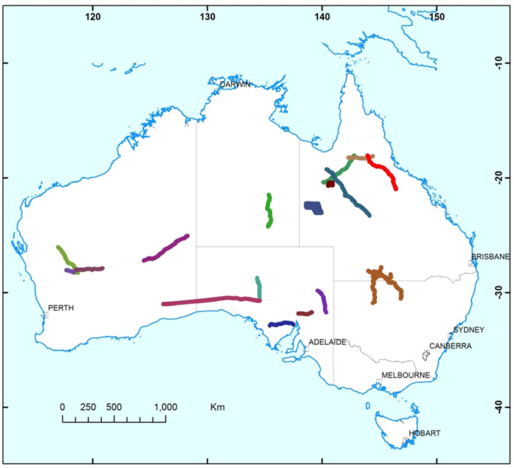
Map of Australia showing recent regional MT surveys
Surveys and Datasets
Completed MT surveys and datasets (2007-present)
The magnetotelluric surveys completed as part of Geoscience Australia's MT Program are outlined below. The processed data, model and report for these surveys are available for download using the links provided.
The survey name, number of stations, survey time, and the release date, are available at the following link: https://pid.geoscience.gov.au/dataset/ga/122188
The relevant publications are available at the following link: https://pid.geoscience.gov.au/dataset/ga/122194.
Magnetotelluric Data Location Package: Government Funded Surveys to December 2017
Geoscience Australia, in partnership with the South Australia, New South Wales, Victoria, Queensland, Western Australia, Tasmania and Northern Territory Geological Surveys, has applied the magnetotelluric technique to image the resistivity structure of the Australian continent over the last decade. Data have been acquired at nearly 5000 stations across Australia through the national AusLAMP MT program and regional MT surveys. Most of the data are available at the Geoscience Australia website. These data provide valuable information for multi-disciplinary interpretations that incorporate various datasets. This release package includes ArcGIS shape files and Excel files of MT station locations for the completed AusLAMP and regional surveys up to December 2017.
The data and report (eCat 116721) were released at the following link:
East Tennant Magnetotelluric Survey
As part of Geoscience Australia’s Exploring for the Future Program, Magnetotelluric (MT) data was acquired to the east of Tennant Creek, Northern Territory in 2019. This survey aimed to characterise major crustal structures, to map cover thickness to assist in stratigraphic drill targeting, and to help understand mineral potential in the region. Broadband and Audio Magnetotelluric data were acquired at 131 stations with station spacing of ~2 km to ~15 km in an area of approximately 90 km x 100 km.
The processed MT data in industry-standard EDI files, a 3D resistivity model and 1D probabilistic resistivity-depth models at each station derived from this dataset are available from the following links:
Olympic Domain Magnetotelluric Survey
Magnetotelluric (MT) data were collected across the Olympic Domain in South Australia in 2018. The survey aimed to improve the understanding of the deformation zones and fluid pathways through the entire crust up to the sedimentary cover of the Olympic Domain. The survey was funded by the Geological Survey of South Australia's Pace Copper Initiative and was conducted by Geoscience Australia and the Geological Survey of South Australia.
MT data were collected at 327 stations with station spacing of ~1.5 km to ~10 km. The processed data and the data acquisition report are available from the following link:
Cloncurry Magnetotelluric Survey, Queensland
Geoscience Australia and the Geological Survey of Queensland conducted the Cloncurry Magnetotelluric survey between July and November 2016. The survey area covers the eastern margin of the Mount Isa Inlier, north of Cloncurry. MT data were acquired at 476 sites with a 2 km grid spacing. The data can be used for mapping the basement and crustal architecture in this region.
The processed data (eCat 110141) and report (eCat 116801) were released at the following links:
South-Eastern Mount Isa Magnetotelluric Survey, Queensland
As part of the Mount Isa Geophysics Initiative program, Geoscience Australia in partnership with the Geological Survey of Queensland collected MT data at 138 sites along a 690 km transect in the South-Eastern Mount Isa region in 2014. Results from the data provide new insights into the understanding of the complex crustal structure in this region.
The processed data (eCat 104221) and report (eCat 104222) were released at the following links:
- South-Eastern Mount Isa Magnetotelluric Survey Data
- South-Eastern Mount Isa Magnetotelluric Survey Report
Cover Thickness Estimates in the Coompana Province, South Australia
The Coompana Project is a collaborative project between Geoscience Australia and the Geological Survey of South Australia which aims to provide new pre-competitive geological, geophysical, and geochemical data in the under-explored Coompana Province in South Australia. The magnetotelluric method was used to estimate cover thickness for the pre-drilling program in the region. MT data were acquired at eight proposed drilling sites in February 2017. The results helped to reduce the uncertainty associated with intersecting the targeted stratigraphy.
The processed data (eCat 112942) and report (eCat 112981) were released at the following links:
Southern Thomson Magnetotelluric Survey
Geoscience Australia and the Geological Surveys of Queensland and New South Wales undertook a multi-disciplinary collaborative project to characterise the largely unexplored southern Thomson Orogen region. As part of this project, MT data were acquired in 2014. These data improved understanding of the thickness of cover, local geology, and mineral systems potential of the region.
The processed data (eCat 90086) and report (eCat 111363) were released at the following links:
- Southern Thomson Magnetotelluric Survey Data and Report
- Southern Thomson Magnetotelluric Survey Cover Thickness Report
Yilgarn-Officer-Musgrave Magnetotelluric Survey
In June and July 2011, 487 km of seismic reflection (L199), wide-angle refraction, gravity, and MT data were acquired by Geoscience Australia and the Geological Survey of Western Australia over the western Officer Basin, one of Australia¿s under-explored sedimentary basins with hydrocarbon potential. The survey data builds on the geoscientific knowledge of the crustal architecture, particularly the relationship between the western Yilgarn and central Musgrave cratons and the overlying Officer Basin.
The processed data and report (eCat 75098) were released at the following link:
Youanmi Magnetotelluric Survey
From May to August 2010, 695 km of seismic reflection (L196), gravity, and MT data were acquired by Geoscience Australia and the Geological Survey of Western Australia over the Youanmi Terrane and Eastern Goldfields Superterrane of the Yilgarn Craton (10GA-YU1, 10GA-YU2 and 10GA-YU3).
The processed data and report (eCat 75099) were released at the following link:
Georgina Basin Arunta Inlier Magnetotelluric Survey
During June and July 2009, 373 km of seismic reflection (L192), gravity and MT data were acquired along a north-south trending traverse starting in the Paleoproterozoic Davenport Province. The traverse then crossed the Georgina Basin, Arunta Inlier, and northern part of the Amadeus Basin. The aim of the survey was to image fundamental controlling structures of basin development and to shed light on deformation and fault reactivation expected from the Silurian to Carboniferous Alice Springs Orogeny.
The processed data and report (eCat 72889) are available at the following link:
Gawler-Officer-Musgrave-Amadeus Magnetotelluric Survey
During November and December 2008, MT data were acquired along part of a 634 km seismic reflection line (L190; 08GA-OM1). This traverse followed the railway line from Alice Springs to Adelaide using the railway access road. The aim of this survey was to provide new insights into the crustal architecture of two Neoproterozoic sedimentary basins in central Australia and their tectonic relationship to older (Mesoproterozoic) basement terrains.
The processed data and report (eCat 72890) were released at the following link as part of the GOMA (Gawler-Officer-Musgrave-Amadeus) seismic and magnetotelluric workshop, November 2010:
Gawler-Curnamona-Arrowie Magnetotelluric Survey
Geoscience Australia undertook acquisition of MT data along a seismic reflection traverse (L189) in South Australia as part of the Onshore Energy Security Program in June and July 2008. This survey consisted of three traverse lines, one across the Gawler province (08GA-G1, 253 km), one across the Curnamona province (08GA-C1, 262 km), and one in the Arrowie Basin (08GA-A1, 60.4 km).
The processed data and report (eCat 72862 and eCat 72888) were released at the South Australia Seismic and MT workshop, Adelaide, May 2010.
Isa-Georgetown-Charters Towers Magnetotelluric Survey
During May to October 2007, Geoscience Australia in collaboration with the Geological Survey of Queensland undertook the Isa-Georgetown and the Georgetown-Charters Towers Surveys. These surveys acquired 1200 km of deep seismic reflection (L184 and L185), gravity, and MT data along three traverses, 07GA-IG1, 07GA-IG2 and 07GA-GC1. The survey imaged the eastern boundary of the Mount Isa Province across the Georgetown Province and southeast through the Charters Towers region.
The processed data and report (eCat 72864) were released at the North Queensland Seismic and MT Workshop, Townsville, June 2009.