Broken Hill managed aquifer recharge
Last updated:7 June 2023
Project completed 2012
Background
The Broken Hill Managed Aquifer Recharge (BHMAR) project investigated groundwater-related options to help secure Broken Hill's water supply during drought; reduce evaporation and improve water efficiency at the Menindee Lakes Storages; protect the local environment and heritage; and return up to 200 gigalitres (GL) of water to the Murray-Darling Basin.
The project was a key element of the Federal Government's 2007 election commitment to improve the management of the Menindee Lakes area in far western New South Wales. The project was managed by the (former) Australian Government Department of the Environment.
In southern Australia, recent droughts and predictions of a drier future have led to innovative strategies to improve water security for regional communities and industries, while also delivering environmental benefits. Of particular concern is the Murray-Darling Basin, where the Millennium Drought adversely affected many communities, industries and the environment. Although heavy rains and flooding broke the drought from late 2010 onwards, longer-term strategic solutions are needed to protect communities against future droughts and achieve a healthier Basin.
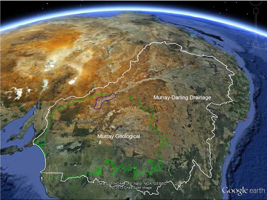
Location of the BHMAR projectarea (purple line) spanning a portionof the Lower Darling valley withinthe Murray Geological Basin (green line)and the Murray-Darling river catchmentarea (white line)
Outcomes
Beginning in 2008, the BHMAR was the largest hydrogeological investigation undertaken by the Australian Government for over 30 years. This innovative project delivered outcomes to improve water security by using aquifers during drought periods to reduce dependence on surface water resources. Key findings from the BHMAR project included:
- Identifying a priority site (Jimargil) that could provide enhanced drought security for Broken Hill. There are several groundwater-related options at this site. These take a conjunctive approach to water management by using surface water when it is abundant and relying on groundwater extraction during drought conditions.
- Groundwater supply options would provide significant water quality benefits for the Darling River and water supplies for Broken Hill and Menindee during drought periods. This would also enable changes to the Menindee Lakes Storage to provide substantial water savings with significant downstream benefits in dry years.
- Discovering potential groundwater resources beneath the Darling River floodplain at Menindee Lakes. These resources are estimated to contain between 2100 and 4400 gigalitres of fresh to acceptable quality groundwater in 14 discrete targets at depths of 25 to 125 metres below ground. These estimates are for total aquifer storage and do not represent the amount of groundwater that could be sustainably extracted (which would be significantly smaller).
Outputs
The Summary Report (report 5) includes key findings and recommendations for potential groundwater resource option across the BHMAR study area, and possible alternative water supply options for Broken Hill. This report is supported by four scientific and technical reports (reports 1-4).
All reports are available as free digital downloads.
- Final Report 1: BHMAR Project: Data acquisition, processing, analysis and interpretation methods. This report details the investigative program and includes details of the data acquisition, processing analysis and interpretation methods.
- Final Report 2: BHMAR Project: Geological and hydrogeological framework and conceptual model. This report presents results from geological, hydrogeological and hydrogeochemical investigations, including 3D geological and hydrogeological frameworks and a new hydrogeological conceptual model.
- Final Report 3: BHMAR Project: Securing Broken Hill's water supply: Assessment of conjunctive water supply options involving managed aquifer recharge options at Menindee Lakes. This report details the findings of investigations into groundwater supply options for Broken Hill within a 20 km radius of Menindee. These options include groundwater extraction and managed aquifer recharge (MAR).
- Final Report 4: BHMAR Project: Assessment of potential groundwater resources and underground storage options in the Darling Floodplain. This report outlines investigations to identify groundwater resources and potential MAR options in the BHMAR project area of the Darling Floodplain.
- Final Report 5: BHMAR Project: Assessment of conjunctive water supply options to enhance the drought security of Broken Hill, regional communities and industries - summary report. This summary report provides the scientific findings of the BHMAR study (Phases 1-3).
Supporting data, analytical, interpretation and product generation methods are included in fifteen accompanying appendix volumes (Apps et al., 2012). Project data and products are also available in the BHMAR project GIS data package (Gow et al., 2012a).
The final project reports were reviewed by scientific experts from Geoscience Australia and the CSIRO. External reviews were undertaken by independent consultants within Australia, as well as an expert panel from the United States Geological Survey (USGS). The project was guided by a Steering Committee with representatives from the Australian and NSW governments.