


30 years of Australia at its barest
4 December 2019
Geoscience Australia and the Australian National University (ANU) are celebrating a collaborative effort to create a single cloud-free image of Australia’s soil and rock cover – effectively stripping our landscape bare.
Titled ‘bare earth’ this world-first research, which compiles thousands of satellite images from the past 30 years, has now been published in the journal Nature Communications.
Geoscience Australia’s Regolith Geoscientist Dr John Wilford worked with Dr Dale Roberts at ANU to develop the method to remove the effects of seasonal vegetation, cloud cover, and complexities caused by fires and agriculture.
“Bare earth is a vividly clear satellite image that improves our understanding of the true nature of the soil – right across Australia,” Dr Wilford said.
“This information is crucial when it comes to deciding how we use the land and where we choose to explore for resources underground.
“We can also draw on this bare earth imagery and its ability to reflect annual changes in bareness, to monitor and assess soil health and land degradation over time.”
The team used data from Geoscience Australia’s Digital Earth Australia program and processed it with the National Computing Infrastructure supercomputer, located at ANU.
“This satellite data is an invaluable resource for getting a clear picture of the whole Australian continent right down to the bare soil view,” Dr Roberts said.
“If you want to plant trees or crops, you need to understand the best place to plant them – which means understanding the soil.
“Similarly, being able to map surface mineralogy and geochemistry from space can be used by the mining industry to better understand the mineral potential of a designated area.
“The algorithm developed to produce this image has also been recognised internationally.”
As for what the breakthrough method means more broadly, Dr Wilford said it is likely to have significant implications for improving the application of satellite imagery for geoscience and environmental studies, at a national and global scale.
Research for the joint collaboration was undertaken as part of the Exploring for the Future program.
More information
- Nature Communications article
- Digital Earth Australia
- National Computational Infrastructure (ANU supercomputer)
- Exploring for the Future program
- National Map
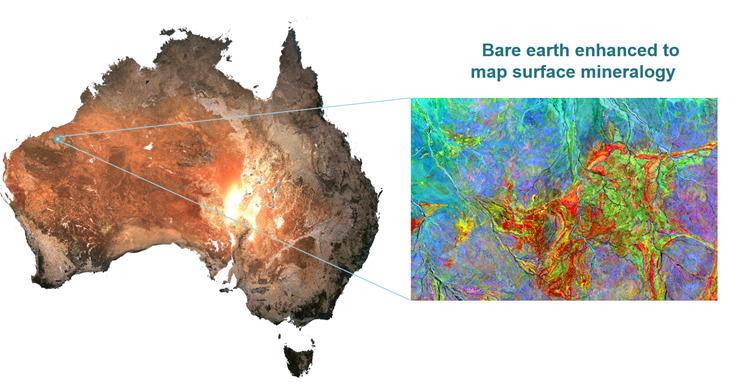
Above left: bare earth dataset in ‘true’ colour bands 3 (red), 2 (green) and 1 (blue). Above right: Processed bare earth datasets highlighting the distribution of clay (red), iron oxides (green) and silica (blue).